Mitchelstown,
Cork,
Ireland
Coordinates: 52.259818, -8.263854

Coordinates: 52.259818, -8.263854
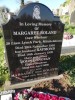
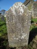
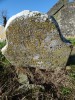
| Photo | Grave | Name | Surname |
|---|---|---|---|
 |
CO-BRGW-176 |
|
|
 |
CO-BRGW-177 |
|
|
 |
CO-BRGW-178 |
|
|
 |
CO-BRGW-179 |
|
|
 |
CO-BRGW-180 | ||
 |
CO-BRGW-181 |
|
|
 |
CO-BRGW-182 |
|
|
 |
CO-BRGW-183 |
|
|
 |
CO-BRGW-184 |
|
|
 |
CO-BRGW-185 |
|
|
 |
CO-BRGW-186 |
|
|
 |
CO-BRGW-187 |
|
|
 |
CO-BRGW-188 |
|
|
 |
CO-BRGW-189 |
|
|
 |
CO-BRGW-190 |
|
|
 |
CO-BRGW-191 |
|
|
 |
CO-BRGW-192 |
|
|
 |
CO-BRGW-193 |
|
|
 |
CO-BRGW-194 |
|
|
 |
CO-BRGW-195 |
|
|
 |
CO-BRGW-196 |
|
|
 |
CO-BRGW-197 | ||
 |
CO-BRGW-198 |
|
|
 |
CO-BRGW-199 | ||
 |
CO-BRGW-200 |

![]()
This site has been surveyed as part of a community heritage project by Historic Graves in conjunction with the Mitchelstown Heritage Society and has been funded by the Heritage Council Grants Scheme 2011 (Heritage Education, Community & Outreach Scheme).