Aug
02
2023
This graveyard is in the townland of Dunnaman, in the parish of Croom (Or recently moved to Adare?) and in the barony of Coshma. The townland lies west of the village of Croom and the N20, South east of the village of Adare, and east of the R519.
Dunnaman translates in Irish to Dun na mBeann, (www.logainm.ie). Dun means fort and ‘binn’, ‘beann’ and ‘na mbeann’ means ‘peak’, ‘cliff’ ‘point’, ie. ‘The Fort of the Points’. The fort refers, at least in later times, to Dunnaman Castle which lies 370m south west of the church and graveyard. The name was transferred to the townland, church and graveyard. In 1615, the church was described as ‘the church of Villa Trostany, alias Donaman, which had a vicar belonging to the rectory at Croom, (www.archaeology.ie). By the 19th century, the church was dedicated to the Holy Trinity.
(The Catholic Church in Adare village is also dedicated to the Holy Trinity.)
The ruined church and graveyard are part of what was once an ecclesiastical enclosure, probably dating to the late 12th or early 13th century. Aerial photographs show extensive earthworks in the surrounding pastureland to the north, east and south of the graveyard walls. Curving ditches to the north and south suggest an enclosure with a diameter of 168 m.
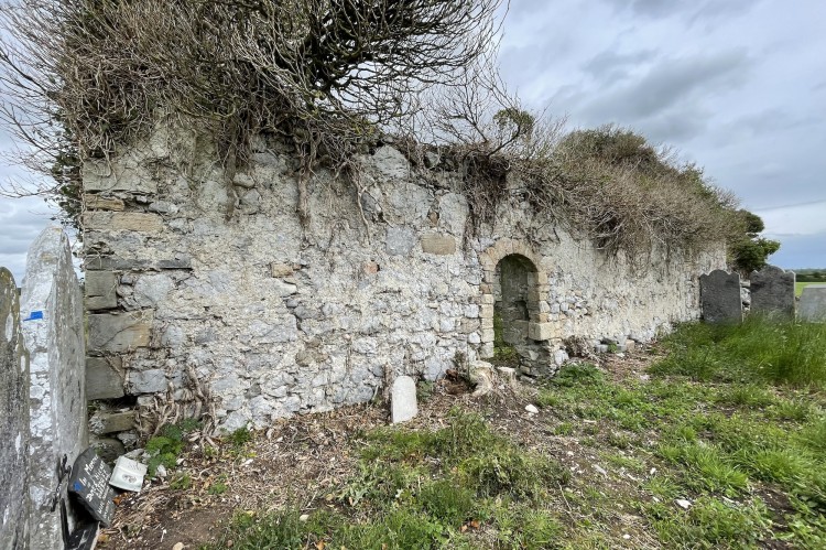
The graveyard is enclosed by a limestone stone wall, with a single iron entrance gate in the south wall. The church which is located in the southern half of the graveyard is a ruin and is partially clad in ivy. It is composed of a nave and a chancel with two sandstone arched doorways intact. The walls are composed of rough limestone and small boulders.
A total of 41 memorials were identified during the summer of 2022. The headstones date from the early 19th century to the present day. The earliest memorial is no.023 commemorating the burial place of John Benson who died in 1805. No 18th century memorials were recorded.
The following surnames were recorded; Lynch, Lane, O’Shea, McMahon, Toomey, Ahern, Cavanagh, Shire, Benson, Conway, Sheehy, Walsh, Gleeson and Moriarty.
Interesting Facts
Some of the early 19th century headstones are elaborately carved. They display the skill and craftsmanship of the monumental sculptors of that time.
Memorial number 022 (Historic Graves.ie) has unusual iconography. Roman soldiers with spears at the feet of a crucified Christ. It is the burial place of Catherine Mulqueen (née Sheehy) who died in 1831. The sculptor’s surname Hayes, is carved at the base of the headstone.
A box tomb on an overground vault enclosed by a railing is located close to the west wall of the graveyard. This is number 011 and it marks the burial place of the Sheehy family of William St. in Limerick. It dates to 1844.
Another interesting headstone with a crucified Christ is memorial no. 005. A ladder and a crowing cock are also carved. It is the burial place of Elizabeth Hartigan (nee Toomey) who died in 1833. The sculptor’s name, Dennis O’Sullivan, is carved at the base of the headstone.
In 1865, The Countess of Dunraven recorded a water font within the interior of the ruined church, (Archaeology.ie). Unfortunately there is no sign of it now. It measured 60cm square.
Dunnaman Castle is located 370m south west of the church ruin and graveyard. It is a three storey tower house with an attached late 18th century (1790-1810) two storey farmhouse on a working farm. (National Inventory of Architectural Heritage). Fragmentary remains of a bawn wall 11m east of the castle can still be seen. Nineteen century outbuildings are now located within the bawn area. The bawn wall may not have been contemporary with the castle and may have been added as late as the 18th century.
There is a Sheela-na-gig positioned 6m high on the east wall of the tower house, probably at the second floor level. It depicts a woman with splayed legs showing vulva. The stone carving is on a framed slab which measures 68cm square, (www.archaeology.ie.). It is reputed to be the largest Sheela-na-gig in the country.
No 18th century memorials were recorded in the Historic Graves survey of Dunnaman Graveyard.
This post was researched and written as part of a grassroots heritage tourism project (www.incultum.eu) in collaboration with Ballyhoura Development CLG (https://www.ballyhouradevelopment.com/), Cork Co. Council (https://www.corkcoco.ie/en) and Limerick Co. Council (https://www.limerick.ie/council). The stories were initially gathered during a community survey of the graveyard. They form part of the Historic Graves Project Destination for Ballyhoura (https://historicgraves.com/destination/ballyhoura).


